
LandScope Chesapeake provides a map reports tool that quickly summarizes a variety of land protection information for jurisdictions and watersheds in the Chesapeake Bay watershed.(Image: LandScope Chesapeake)
How can you quickly find how much land is protected within a county? Or a watershed? Or find out what the make-up of that protected land is – how much is owned by a particular type of owner; or how much is forested?
We’ve got an updated tool for that!
LandScope Chesapeake provides a slew of curated maps related to land conservation and the Chesapeake Conservation Partnership’s land protection goals. It also includes a “map reports” tool for quickly viewing summary information on protected lands.
The Chesapeake Bay Program GIS team recently worked with NatureServe to update of the Landscope Chesapeake Protected Lands Reporting Tool. It now uses a map layer compiled in 2018 and early 2019 that represents the most up-to-date comprehensive, Chesapeake watershed-wide protected lands data.
This most recent and best available dataset was assembled directly from authoritative sources, including Chesapeake Bay Program partners, State and Federal agencies and national datasets including Protected Areas Database of the United States (PAD-US) and the National Conservation Easement Database (NCED). The data collected were, in most cases, current as of the end of 2018.
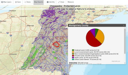
The reporting tool allows users to view pre-calculated statistics to provide acreage information by owner, land cover, and percent protected at the State, County, HUC12 watershed, and entire watershed scales.
Visit Landscope Chesapeake to view the most recent protected lands data and use the tool. Just click on “Map Reports” above the map to get started. For information on how to use LandScope and the report tool watch this short video. The report tool is described at about 3:50 in.
LandScope Chesapeake has been coordinated by the Chesapeake Conservation Partnership since 2012 to present a wide variety of important conservation mapping data in an easy to use format. Administered by Partnership member NatureServe, LandScope Chesapeake is partially supported by financial assistance from the National Park Service Chesapeake Gateways program and by mapping and analytical data from a wide variety of partners.
Lightning Update is a regular communication of the Chesapeake Conservation Partnership. Any opinions expressed are those of the authors and do not necessarily reflect positions of the Partnership or member organizations.
To share a success story, news, or important event, send your information to:
Support for the Chesapeake Conservation Partnership is provided by:
National Park Service Chesapeake
EPA Chesapeake Bay Program
USDA Forest Service
Pennsylvania Department of Conservation & Natural Resources
Maryland Department of Natural Resources
Virginia Outdoors Foundation
US Fish & Wildlife Service
Chesapeake Conservancy
The Chesapeake Conservation Partnership is co-convened by:

")