
CCP 30×30 Dashboard
Written by Louis Keddell and Alicia Sabatino
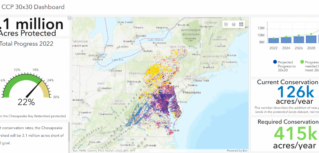
The Chesapeake Conservation Partnership (CCP) is excited to announce the new 30×30 progress dashboard. This user-friendly resource empowers the public to track our collective progress toward our goal of protecting 30% of the Chesapeake Bay Watershed from development to benefit our shared goals to protect and improve farms, forests, habitat, heritage, and human health by 2030. The dashboard allows people to determine not only where we are with current goals but also where we need to go, both in terms of acreage left to protect and also geographically where unprotected lands currently lie on the landscape.
This data dashboard features a center map pane showing the 2022 protected lands dataset along with all of the CCP Conservation Atlas layers pertaining to priority conservation influences and goals. The Conservation Atlas layers provide context for land conservation efforts throughout the watershed and can help users identify areas for protection that may meet multiple thematic priorities. Users can view the legend and turn layers on and off with the hamburger bar on the top right of the map pane.

A northern blue flag iris blooms at Mabel P. & Paul T. Goethchius Wetland Preserve in
Caroline, N.Y.
The dashboard also features several indicators about the progress of land conservation in the Chesapeake Bay watershed, including gauges and charts driven by the underlying data and statistics on protected land in the watershed.
Dashboard indicators*:
- 9.1 million acres is the total area conserved in the watershed, as reported in 2022 from the Bay jurisdictions.
Total 2022 progress toward protecting 30% of the watershed from development by 2030 (based on a 2010 data baseline and available land area for protection). - The current rate of conservation reported in the dashboard is 126k acres per year on average (given 2010-2022 data trend).
- The dashboard number describes the addition of new protected lands in the protected lands dataset, not necessarily the year the land was protected. This information is based on the best available protected lands data provided by state and federal sources.
- 415k acres per year will need to be conserved moving forward in order to meet the 30×30 goal. This figure is based on an average of acreage remaining.

The blue crab winter dredge survey is conducted by staff and crew with the Maryland
Department of Natural Resources in Harris Creek in Talbot County, Md.
The chart on the top right displays the projected progress for conservation in the Chesapeake Bay watershed (blue bars) as well as the progress needed to get to 30×30 protected lands goals in total acres (green line).
You can track progress and find this dashboard by going to www.chesapeakeconservation.org.
*This dashboard is based on the 2022 protected lands dataset, which is the best information available from State and Federal data providers. Progress and trends in conservation acreages are estimates and may be missing unreported data, either current or historical. Please refer to Chesapeake Progress for more information on the dataset and the associated methodology.
1:CCP
2:Chesapeake Bay Program
3.Chesapeake Bay Program
Lightning Update is a regular communication of the Chesapeake Conservation Partnership. Any opinions expressed are those of the authors and do not necessarily reflect positions of the Partnership or member organizations.
To share a success story, news, or important event, send your information to:
Support for the Chesapeake Conservation Partnership is provided by:
National Park Service Chesapeake
EPA Chesapeake Bay Program
USDA Forest Service
Pennsylvania Department of Conservation & Natural Resources
Maryland Department of Natural Resources
Virginia Outdoors Foundation
US Fish & Wildlife Service
Chesapeake Conservancy
The Chesapeake Conservation Partnership is co-convened by:

")