
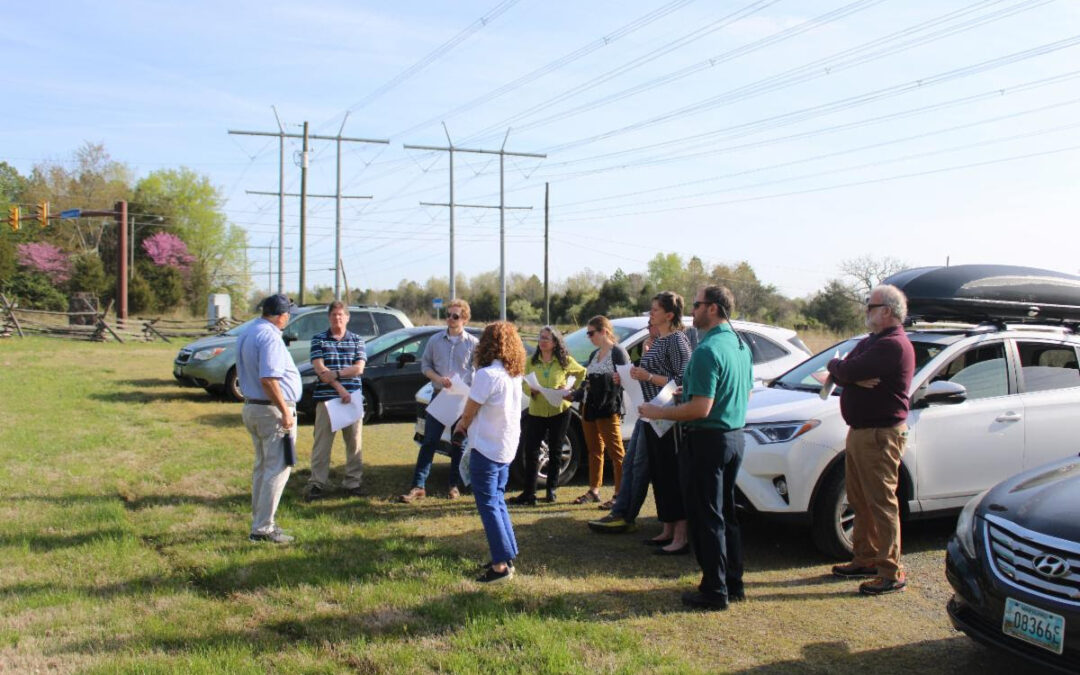
Participating members of the Chesapeake Conservation Partnership Steering Committee gather at Manassas National Battlefield HQ prior to the field trip.
Written by Mike Bonnell
Last month’s Chesapeake Conservation Partnership Steering Committee meeting took place in Warrenton, Virginia. Prior to the meeting, some of the participating Steering Committee members were taken on a field trip organized by Chris Miller and John McCarthy of Piedmont Environmental Council to view firsthand the impact that data centers and energy infrastructure has had on the landscape of Northern Virginia.
We woke up to a beautiful sunny morning at Manassas Battlefield, but as we gathered to depart, it was hard to ignore the clear-cut corridor and the transmission lines towering over us. The massive structures and their implications for the rest of the land use in the area made for a reminder of a possible future. As we passed data center after data center – blocky buildings with multiple backup diesel generators – we saw the scale of the growing land use and solar siting issue in Virginia.

A 500 kilovolt transmission line running alongside the border of Manassas National Battlefield.
Most of the solar that has been built and is planned to be built is to serve a massive planned data center corridor in Northern VA. As Virginia is becoming the new home of “the cloud,” more and more companies are packing up and moving their data infrastructure to the state. Data centers have large footprints and require an immense amount of power. To be exact, one data center facility uses as much as 30+ megawatts (MW) of power, the equivalent of 7,500 homes at peak use. A 2019 report by Greenpeace estimated that electricity demand from existing Virginia data centers and those under development is approaching 4.5 gigawatts (GW), or roughly the amount of power it would take nine large (500-megawatt) coal power plants to produce. Dominion Energy recently stated it would need to build more fossil fuel and nuclear energy (and delay planned decommissioning of existing fossil fuel burning energy production facilities) as well as solar to keep up with demand. According to S&P Global, with the rise of Amazon, Microsoft, and other companies’ energy needs, by 2030, some projections expect data centers creating an energy demand of over 30 GW.
Some tech companies have made pledges to be carbon neutral and power these data centers with renewable energy to lessen the enormous carbon footprint of this new energy demand. Lessening our dependence on fossil fuels and non-renewable energy is an essential part of the fight against climate change. To create a cleaner future, it is important that we strive for 100% renewable energy. But how much land would it take to generate and transmit 30 gigawatts of energy?
Piedmont Environmental Council estimates that to generate that amount of energy, it would require about 5% of the land area of Virginia, equivalent to 1.3 Million acres of solar. Can we meet this demand with as small of a footprint as possible and while still conserving millions of acres and reaching our goals to conserve 30% of the Chesapeake Bay Watershed by 2030?

An Amazon/AES solar facility in Spotsylvania County, VA
The land-use issues posed by solar can be numerous when developers look to work as quickly and cheaply as possible. Large-scale solar facilities often require the flattening of land, as well as the installation of roads and solar panels that are considered impervious surfaces. This results in the all-too-well-known runoff issues that can be prevented by the ecosystem services provided by forested land. Because of the demand for energy, and the massive bank accounts of corporations that need it, developers are able to outcompete conservationists and buy up property that could remain green.
To make sure that solar is used in the most efficient and land-conscious way, paying close attention to siting, or the locations solar is built, is vital. Instead of using forest or farmland, called greenfields, solar can be placed on rooftops, over parking lots and in other areas that are already degraded, called brownfields. This report from the Conservation Innovation Center (CIC) housed at the Chesapeake Conservancy details a project on solar siting in Baltimore County, Maryland. The CIC investigated the available brownfield area in the county and found that there are over 33,000 acres available for use that would not impact already existing forest land. Investigating brownfields in Virginia could provide the area needed to provide the massive planned power load.

The Remington solar facility produces 25 MW on 250 acres in Northern Virginia.
As our tour began at Manassas National Battlefield Park Headquarters, we noted that the Prince William Digital Gateway was across the street and extended for over 2,100 acres. The area, known as the Rural Crescent, is the former agricultural reserve of Prince William County but is now poised to become a major new data center and infrastructure development.
We made our way through the rapidly developing areas to the south, and the tour traveled through the type of development in Virginia’s present and future. For example, an area identified in the Prince William County Comprehensive Plan as Innovation Park, with a data center overlay with a goal of over 20 million square feet of data centers and distribution. Further north, along the same transmission line corridor comprised of dual 500 Kilovolt lines, carrying close to 6 GW of power, is an area known as “Data Center Alley,” which has nearly 30 million square feet of data centers requiring in excess of 6 GW and increasing in the future to 15-20 GW.
We continued south, where over 5 million square feet of existing and developing data centers and warehouse fulfillment centers were seen from I-66. Further south, we viewed an additional 7-10 million square feet of existing and developing data center, warehouse and support facilities that were evident on both sides of the Prince William Parkway.
The tour ran through an area called Nokesville, also developing large projects, but more of a mix of retail as well as data center and warehouse, with large home developments to the east and west in Prince William. The map indicates multiple sites owned by data center developers and others where industrial-scale solar is proposed totaling over 2000 acres. The tour concluded near the existing Remington solar facility, approximately 25 MW on 250 acres near a natural gas peaking plant and existing transmission infrastructure.

A map of the tour taken by the Steering Committee. Beginning at Manassas Battlefield HQ, then proceeding past the data center corridor and proceeding south towards Remington. The Catlett stop was omitted for time-saving purposes. Orange and Red borders represent Solar and Data Center development, respectively.
This tour allowed CCP Steering Committee members to see firsthand the impacts and scale of the problems posed by data centers and solar. The data center issue is currently concentrated in Virginia. However, as more and more tech companies come to the Chesapeake Bay region, the massive amount of solar and transmission infrastructure required to support them is at risk of spreading and affecting the rate of land conservation across the watershed. Collaboration will be required to plan for and build out solar infrastructure in a way that creates the most benefit without compromising land that already provides valuable ecosystem services. While these new energy demands make for significant challenges in the world of land conservation, there are also vast opportunities to find more creative solutions through collaboration. We can increase awareness of best practices and work with all of our partners to pave the best path forwards toward conserving 30% of the watershed by 2030 in the most sensible way possible.
- Mike Bonnell
- Mike Bonnell
- Hugh Kenny – Piedmont Environmental Council
- Bri West – Piedmont Environmental Council
- Piedmont Environmental Council
Lightning Update is a regular communication of the Chesapeake Conservation Partnership. Any opinions expressed are those of the authors and do not necessarily reflect positions of the Partnership or member organizations.
To share a success story, news, or important event, send your information to:
Support for the Chesapeake Conservation Partnership is provided by:
National Park Service Chesapeake
EPA Chesapeake Bay Program
USDA Forest Service
Pennsylvania Department of Conservation & Natural Resources
Maryland Department of Natural Resources
Virginia Outdoors Foundation
US Fish & Wildlife Service
Chesapeake Conservancy
The Chesapeake Conservation Partnership is co-convened by:

")