
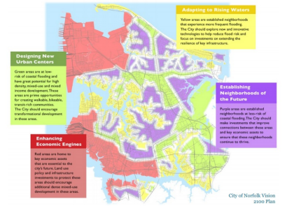
Norfolk, Virginia is at the forefront of facing rising sea level, as “nuisance flooding” (image below) is becoming ever more frequent. The city’s Vision 2100 Plan (map above) addresses coastal flooding head on. (Map: Norfolk; Photo: Skip Stiles)
A Note: We usually keep Lightning Updates to a single subject, except today, when we’re adding a remembrance of a friend of the Chesapeake following our main story. Please read on.
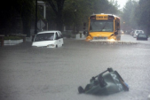 Flooding is an increasing problem in communities around the Chesapeake watershed. As storms become more intense and sea level rises, cities and their residents face serious challenges. Few communities are closer to the problem than those at the mouth of the Bay, in and around Norfolk, Virginia, pictured here. One study reports “nuisance flooding” in Norfolk has increased 325% since 1960 and that by 2049 there may be over 200 flood events each year.
How are cities and land conservationists addressing this threat? Wetlands Watch and the Living River Trust recently held a webinar to report on two pilot projects, one in Norfolk and one in Chesapeake, focused on converting frequently flooded residential properties to conserved open space. Here’s an overview.
The City of Chesapeake has acquired 36 parcels through an open space acquisition program funded by Federal Emergency Management Agency (FEMA) hazard mitigation grants. Once structures are removed, the properties must be left undeveloped in perpetuity. Annual mowing costs are $2,378 per parcel or a total of $85,608. To reduce these costs, the City and Living River Trust are exploring whether a land trust could facilitate adaptive land management through accepting land acquired through the FEMA program. Apparently there are few examples to date of land trusts accepting FEMA supported acquisitions, so the pilot is breaking new ground and could generate useful templates for others.
The City of Norfolk has a new zoning ordinance with innovative mechanisms for addressing flooding. The ordinance creates a market incentive for locating new development in higher elevation, lower-risk areas. This occurs through a “resilient quotient program” where developers need to meet a certain standard and can acquire additional resilience points by extinguishing development rights in lower-elevation, higher-risk coastal resilience areas. Living River Trust and Wetlands Watch are collaborating to explore how this new approach will work in practice–or what adjustments may need to be made–by running four sample parcels through the process.
To learn more about this work you can view the entire webinar or download a copy of the webinar slideset. The results of these pilots should be helpful for the large number of communities throughout the Chesapeake watershed facing similar issues.
A Conservationist & Friend of the Chesapeake
 It seems fitting to marry a story focused on how planning and land conservation can advance ecologically sound land management with a note on the death last week of Michael Clarke. Michael was one of many planners and conservationists influenced by Ian McHarg’s teaching of ecological planning at the University of Pennsylvania during the 1960s, 70s and 80s. But Michael became deeply influential in his own right, advancing ecological planning on the ground and in communities.
In the 1990s as President of Natural Lands, a land trust which today protects almost 50,000 acres in Pennsylvania and New Jersey, he led pioneering work on conservation planning and conservation development. Natural Lands’ major programs in advising communities on planning and “conservation by design” are due largely to Michael’s vision and leadership.
But for much of the past two decades, Michael, often in collaboration with his wife Liz Clarke, helped advance Chesapeake conservation through sound planning. Liz and Michael, working through WRT, a planning and design firm in which Ian McHarg was once a partner, were the primary planners for comprehensive management plan for the Captain John Smith Chesapeake National Historic Trail. During the process, Liz and Michael loaded kayaks on the roof of their car, drove from their home in Lake Placid, New York, and paddled multiple rivers in Virginia and Maryland to understand the trail landscape up close. Michael went on to develop the first more detailed plan for the trail’s James River segment and later also developed the trail’s conservation strategy.
In 2012 Chesapeake watershed land conservation partners convened in Shepherdstown, West Virginia for what would become a pivotal meeting. Michael wrote the report documenting that meeting, framing out the principles of what would soon become known as the Chesapeake Conservation Partnership.
Michael was a terrific person, always rewarding to talk with. His principled, thoughtful, rigorous approach to planning and conservation was profoundly helpful and impactful. He would always push and prod for the right thing, the right approach. There are always a few people in a field in whom one can feel completely confident and comfortable. Michael was one of those.
Lightning Update is a regular communication of the Chesapeake Conservation Partnership. Any opinions expressed are those of the authors and do not necessarily reflect positions of the Partnership or member organizations.
To share a success story, news, or important event, send your information to:
Support for the Chesapeake Conservation Partnership is provided by:
National Park Service Chesapeake
EPA Chesapeake Bay Program
USDA Forest Service
Pennsylvania Department of Conservation & Natural Resources
Maryland Department of Natural Resources
Virginia Outdoors Foundation
US Fish & Wildlife Service
Chesapeake Conservancy
The Chesapeake Conservation Partnership is co-convened by:

")